


PRESS RELEASE
COMMUNICATION AND MEDIA TEAM OF AIS FORUM 2023 SUMMIT
No.37/SP/TKM-AISFORUM2023/10/2023
Nusa Dua, Bali, October 8, 2023 – Indonesia is a maritime country with two-thirds of its territory consisting of water. According to the results of the United Nations Convention on the Law of the Sea (UNCLOS) held on December 10, 1982, in Montego Bay, Jamaica, Indonesia's maritime area covers 3,257,357 square kilometers (km²). Additionally, Indonesia has a coastline stretching 81,290 km, making it the second-longest in the world after Canada.
Given this reality, understanding every detail of the characteristics and potential of Indonesia's waters presents many challenges. Indonesia requires oceanographic data not only for national interests but also to play a more significant role on the global stage. Measurement is crucial because Indonesian waters feature an ocean current system known as the Indonesian Throughflow, which can influence global oceanic conditions.
To collect such data, instruments are needed that can cover the entire maritime territory in real-time and measure precisely in both shallow and deep waters. Unfortunately, no existing instrument can perform periodic measurements while being suitable for all types of Indonesian waters.
This challenge inspired Noir Primadona Purba to develop a digital technology-based water monitoring and measurement tool. A lecturer at the Department of Marine Sciences, Faculty of Fisheries and Marine Sciences, Padjadjaran University, Bandung, he successfully created ARHEA, an acronym for Advanced Drifter GPS Oceanography Coverage Area.
ARHEA: A Game-Changing Maritime Monitoring Tool
ARHEA is a 1-meter-long yellow aluminum tube with a 144-millimeter diameter and weighs approximately 15 kilograms. The tube is equipped with various sensors, batteries, data storage, a global positioning system (GPS), and communication systems via radio and satellite. In both open and closed waters, the tube floats due to its built-in buoy, allowing it to follow water currents. It functions similarly to an aerial drone but moves underwater.
ARHEA can be deployed in closed water bodies such as reservoirs and lakes, as well as very shallow waters. It is capable of diving to a maximum depth of 200 meters and is primarily used to measure currents using the Lagrangian method.
Before reaching its maximum depth, sensors send a signal to prompt ARHEA to ascend using a rotor-driven mechanism installed at the bottom of the tube. ARHEA operates on a rechargeable battery that requires recharging every three months.
"When it reaches the water's surface, ARHEA transmits the collected data. Once the data transmission is complete (typically in 15-25 minutes), the device submerges again," said Noir Primadona Purba, who was born in Pematangsiantar on January 17, 1982, during an interview on Sunday (10/8/2023).
The sensors installed on ARHEA can be customized according to user needs, measuring atmospheric parameters such as air temperature, humidity, and water pollution levels, as well as water parameters such as salinity, acidity (pH), water temperature, dissolved oxygen (DO), and turbidity.
Additionally, ARHEA can predict fishing grounds and map fish population areas with an accuracy of less than 5 meters from the recorded underwater objects. The device can also function as a marine protected area monitoring tool, making it valuable for institutions related to marine and fisheries management. ARHEA can be deployed using boats or aircraft.
Accurate, Measurable, and Tested
The measurement intervals of ARHEA's sensors can be set by users—every 5, 30, or 60 minutes. The collected data is transmitted via satellite to the Padjadjaran Oceanographic Data Center (Indonesia Sea-Padjadjaran Oceanographic Data Center/ISEA-PDOC), where real-time monitoring results are displayed at www.isea-pdoc.org.
Development of ARHEA began in 2016 through collaboration between Padjadjaran University's Maritime Research Laboratory (MEAL), the Marine Science Institute (MSI) at the University of the Philippines, and PT Robo Marine Indonesia. The first prototype, named GPS Drifter Combined (GERNED), was later renamed RHEA (Drifter GPS Oceanography Coverage Area) before being finalized as ARHEA.
The device has undergone a series of trials in various Indonesian waters, including Pangandaran (West Java) and Pramuka Island (Thousand Islands, Jakarta). ARHEA was also tested in Suva, Fiji. It was introduced internationally at the Archipelagic and Island States (AIS) Forum Summit in Manado, North Sulawesi, on November 1, 2018.
At the forum, ARHEA gained significant interest from international delegations and key stakeholders in the maritime and fisheries sectors. "This is a proud achievement for us because 80% of ARHEA’s materials are locally sourced and it is entirely manufactured in Indonesia, except for the data transmission transmitter, which still needs to be imported," Noir stated.
Given its high value, especially for archipelagic and island nations, the AIS Forum and the United Nations Development Programme (UNDP) have provided full support, including development grants. This support aims to further integrate cutting-edge maritime technology into ARHEA to help ensure a sustainable future for the oceans.
(Reported by Anton Setiawan, Edited by Elvira Inda Sari)
About the AIS Forum
The Archipelagic and Island States (AIS) Forum is a global cooperation platform for island and archipelagic countries, aimed at strengthening collaboration to address global challenges in four key areas:
- Climate change mitigation and adaptation
- Blue economy development
- Marine plastic waste management
- Good maritime governance
The AIS Forum Summit is held to solidify the forum’s role as a hub for smart and innovative solutions and as a collaborative platform for advancing global ocean governance.
For more information, please contact:
Thomas Benmetan, Head of Marketing & Communication, AIS Forum Secretariat (thomas.benmetan@undp.org)
Access press releases, narratives, photos, and videos related to the AIS Forum 2023 Summit at https://s.id/aispedia.
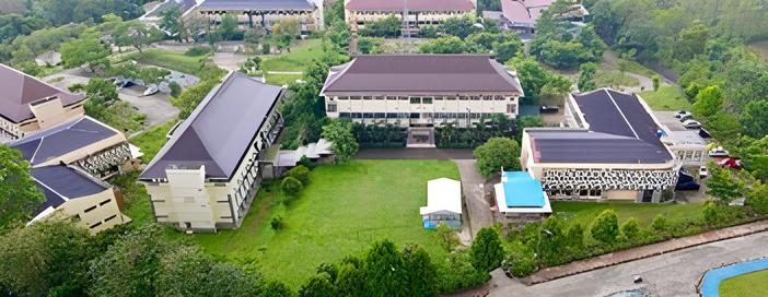
The Maritime Research Laboratory (MEAL) at Padjadjaran University, located in Jatinangor, Sumedang, West Java, was the first development site for ARHEA in collaboration with the Marine Science Institute (MSI) at the University of the Philippines and PT Robo Marine Indonesia in 2016. (Photo: Padjadjaran University Documentation).